MARSHALL STATE FISH WILDLIFE AREA
Marshall State Fish and Wildlife Area, located along nearly 10 miles of scenic Illinois River backwaters, bottomlands and bluffs, lies in the heart of the mallard duck flyway and supports a wide variety of animals, plants and outdoor pursuits.
With an initial land purchase in 1925, the area has grown to include approximately 6,000 acres, of which half is land and half is water divided into three units.
The largest of these is the Marshall Unit, consisting of 3,000 acres east of the Illinois River and adjacent to Route 26. The area headquarters is found here, along with a small campground, boat ramp, fishing channel, hunter check station and hiking trails. Terrain varies from ravine-cut bluffs to bottomland lakes, islands and sloughs.
The Spring Beach Unit contains 1,642 acres (537 acres of water) on the west side of the Illinois River between Sparland and Chillicothe. The unit falls in both Marshall and Peoria counties. There is a 6-acre picnic area, fishing, and access to hunting and hiking trails adjacent to Route 29. The habitat ranges from upland forest to riverbottom to cropland.
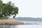
The Sparland Unit, the smallest of the three, consists of 1,280 acres, of which 1,110 acres are water. Lying between Route 29 and the Illinois River, Sparland is predominantly used as a waterfowl hunting area, although at times fishing is quite popular. The backwater is very shallow and boat access is difficult during low water.
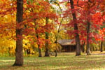
On the east side of Route 26 and the west side of Route 29 are high bluffs containing heavy hardwood timber of oaks, hickories and walnuts interspersed with wildflowers and shrubs. Wildlife includes red, gray and flying squirrels, white-tailed deer, rabbits and other woodland species. Songbirds, owls and hawks are common, particularly during migrations.
Bottomland forests and the backwater lakes comprise the majority of the area. Found here is a wide variety of fauna and flora. Cottonwood, silver maple and willow cover much of the low-lying land, including several large islands. River bullrush and other moist-soil plants thrive at the water?s edge. Deer, raccoon, muskrat, mink and beaver find this habitat to their liking and can sometimes be observed at dawn and dusk. A number of beaver dams dot the backwaters and these are good spots to watch wildlife.
While not as attractive to wildlife as they once were due to heavy siltation, the backwater lakes still attract large flights of waterfowl during migration. Only the brightly colored wood duck, common to the area, remains during the summer to nest and raise its young.
The tall and stately great blue heron also is ground on the backwaters in large numbers, occasionally as many as 75 of these birds can be spotted fishing in the shallow waters at one time. And during winter it is not unusual to see bald eagles soaring above the frozen lakes or perched atop some snag.
Day-UseFishingyes
Huntingyes
Hiking Trailyes
Swimming Beachyes
BoatingLaunch Rampsyes
CampingElectric Sitesyes
WinterActivitiesyes
Camping - Tent and trailer spaces with electricity and water are available. Canoe camping is permitted on the islands except during waterfowl hunting season. Camping permits must be obtained.


 Share Your Marshall State Fish Wildlife Area Photos (click here)