INDIAN BOUNDARY CAMPGROUND
Indian Boundary Recreation Area is the crown jewel of the South Zone of the Cherokee National Forest on the Tellico Ranger District. This family-oriented campground offers a swim beach and picnic area with grills and an accessible picnic pavilion, as well as a fantastic, 3.2-mile hiking and biking trail around the lake. Spectacular mountain views, glimpses of wildlife, and a peaceful setting await visitors who come to Indian Boundary.Opportunities abound for fishing, swimming, boating, wildlife viewing and scenic driving. Other popular activities include hiking and biking the trail around Indian Boundary Lake.
The recreation area contains a swim beach, boat ramp, fishing pier, picnic area and volleyball court.The 87-site campground has electric hookups, water faucets throughout the campground, grills, picnic tables and lantern posts. Modern restrooms add to the comfort of visitors in this natural setting. An on-site campground store sells bread, ice, milk, ice cream and other camping supplies.
ndian Boundary Lake covers 96 acres at an elevation of 1,560 feet, and sits among hardwoods and pines. At the lake, visitors enjoy watching beaver that inhabit an adjacent pond, identifying several species of ducks and other waterfowl and trying their luck at catching bass, sunfish and catfish.
The Cherokee National Forest is located in eastern Tennessee and stretches from Chattanooga to Bristol along the North Carolina border. The 650,000-acre swath of land is Tennessee's only national forest. It lies in the heart of the Southern Appalachians and is home to more than 20,000 species of plants and animals, as well as many rivers, creeks and lakes. Elevations range from 750 to 5,500 feet.The campground is two miles off the Cherohala Skyway, a 43-mile National Scenic Byway that stretches from Tellico Plains, Tennessee, to Robbinsville, North Carolina. Bald River Falls on Tellico River Road 210 is a popular destination. The Pheasant Fields Fish Hatchery also on Tellico River is operated by the Tennessee Wildlife Resources Agency and is the rearing pools for the fish stocking program on Tellico River, Citico Creek, and the Green Cove Pond.
 Backbone Rock Campground
Backbone Rock Campground is open for the 2021 season. Backbone Rock Campground is a small campground situated along the beautiful Beaverdam Creek at an elevation of 2,100 feet in northern Johnson County. This developed campground is popular with those visiting the nearby Backbone Rock, a tunnel originally blasted through the rock ridge for the railway. The
....moreCardens Bluff Campground At nearly 2,000 feet elevation, Cardens Bluff Campground is located on a peninsula overlooking the 6,430-acre Watauga Lake in Carter County, TN. There are 43 sites, primarily for tent camping. There is a bathhouse with showers and flush toilets. No electrical hookups are provided. Day use areas are located nearby for those wanting to take advantage of
....more Chilhowee Campground Located in the Chilhowee Recreation Area, Chilhowee Campground offers a multitude of camping opportunities for both RV and tent sites, many with electric hookups. The day-use area includes McKamy Lake, a swim area with sand beach, picnic sites, a group picnic area, and a bathhouse.
Be Aware Do not use GPS directions GPS coordinates will direct you up
....more Dennis Cove Campground Dennis Cove Campground is now open for the 2021 season. Dennis Cove Campground is a secluded campground along Laurel Fork Creek at an elevation of 2,650 feet in Carter County. This remote developed campground is popular with those seeking a rustic experience. The altitude, creek side location and lush forest surroundings make Dennis Cove particularly
....more Horse Creek Recreation Area Horse Creek Recreation Area is located eight miles from Greeneville, off TN 107 north. This recreation area is nestled into a hardwood cove beside its namesake, Horse Creek. Horse Creek is located in the Chuckey area of Greeneville, TN. The campground is primarily walk-in, tent camping only. With plenty of forest-related activities to do around the
....more Little Oak Campground Little Oak Campground hugs the shores and inlets of beautiful South Holston Lake in Sullivan County, Tennessee. With a view of the Holston Mountain ridgeline and lake islands, Little Oak campsites are a relaxing setting for your vacation. There are 69 universally accessible campsites improved in 2012 including warm showers and a paved access road.
....more Paint Creek Campground Paint Creek Recreation Area elevation 1760 feet is located in Greene County in a mountain cove along Paint Creek. A majority of the widely-spaced campsites have streamside views and are screened by a variety of native plants, including rhododendron, hemlock and laurel.
Be Bear Wise Food storage compliance is strictly enforced. Store all food and trash
....more Parksville Lake RV Campground Located near Parksville Lake, Parksville Lake RV Campground offers well-shaded and nicely spaced campsites accommodating larger RVs. Several sites offer the opportunity for two RVs to camp close together and several are located along a small stream.Picnic tables, grills, and lantern posts are located at each site. A bath house providing flush toilets and
....more Rock Creek Recreation Area Rock Creek Recreation Area is named for the small creek that runs alongside this recreation site. The facilities, creek-fed concrete pond and bathhouse were originally built by the Civilian Conservation Corps in the early 1930s. It is located just outside the town of Erwin, TN at an elevation of 2,300 feet - a welcome respite from the summer heat.
Be
....more South Holston Lake Jacobs Creek Campground is situated along the shores of beautiful South Holston Lake in Sullivan County, Tennessee, at an elevation of 1,730 ft. With a view of miles of undeveloped shoreline and the water, the campsites at Jacobs Creek Campground are a relaxing way to spend your vacation. There are 27 available campsites, 23 of which are reservable,
....more Thunder Rock Campground Thunder Rock Campground is located 1.8 miles northwest of the Ocoee Whitewater Center, just behind TVA Ocoee Powerhouse Number 3. Nestled alongside the Ocoee River, this facility provides 37 regular campsites for popups and RVs less than 20 feet with no elctricity , ONLY site 9 is an electric site for less than 20 feet at 30 amp, and one group campsite.
....more


 Share Your Indian Boundary Campground Photos (click here)
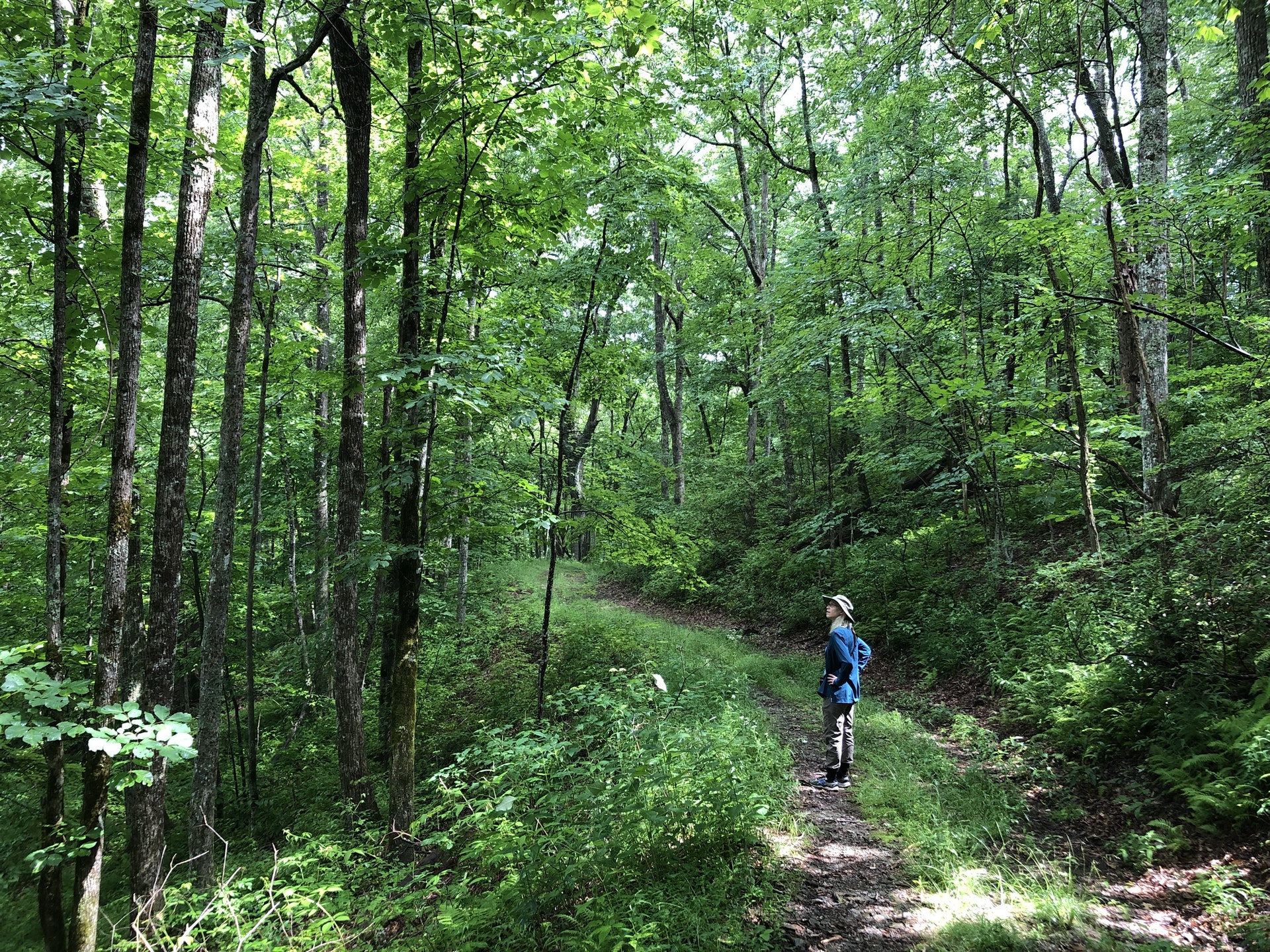