ROCK BRIDGE MEMORIAL STATE PARK
Get away from the bustle of everyday life by seeing some of Missouri's finest karst features such as the rock bridge or by exploring the forests, streams and restored grasslands of Rock Bridge Memorial State Park.
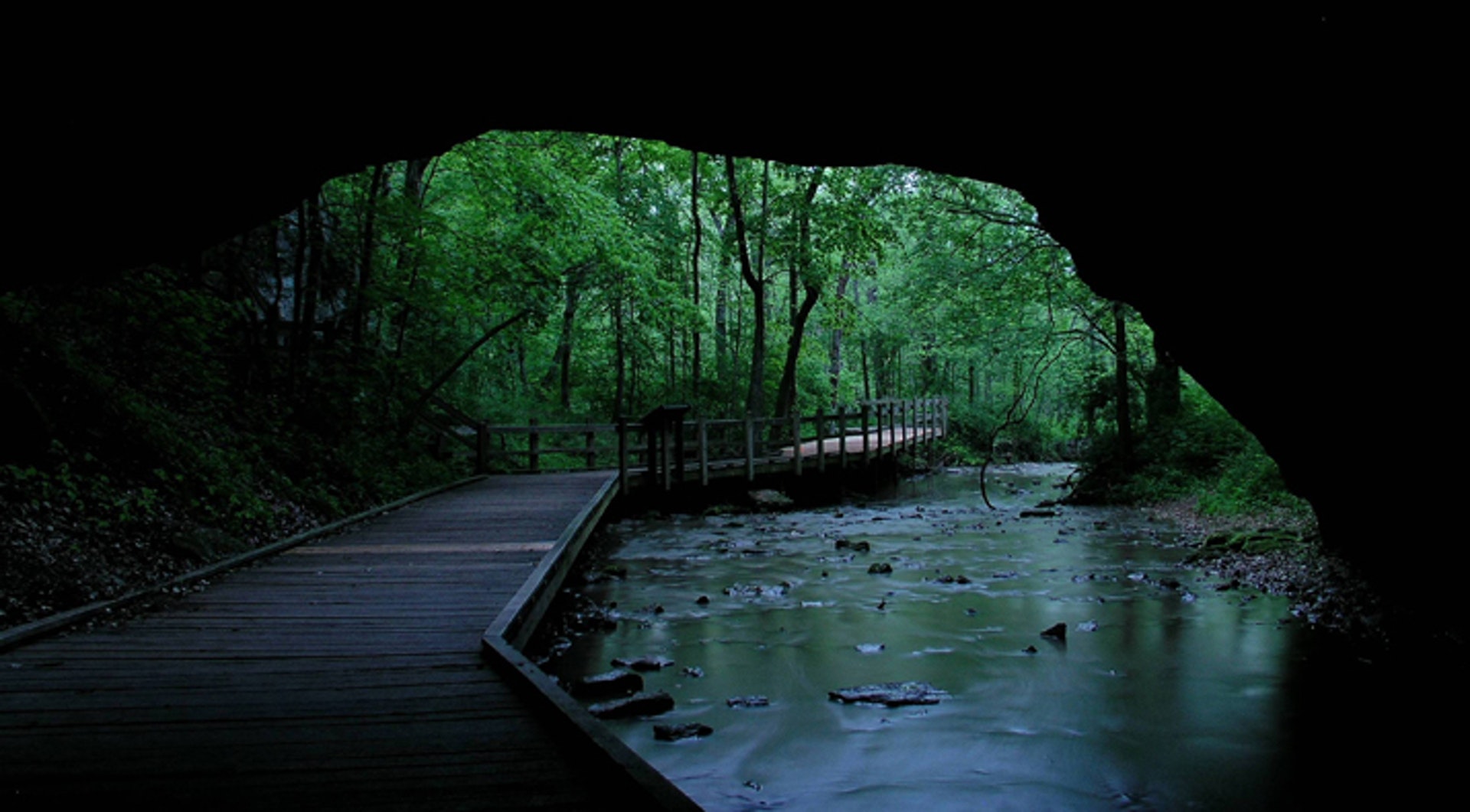
While walking the half-mile Devil's Icebox Boardwalk, visitors will pass both under and over the rock bridge, have the opportunity to explore Connor's Cave on their own, and see an underground stream, small spring and sinkhole. The 15 miles of trails that traverse the 2,273-acre park are always open to hikers and are conditionally open to bicyclists. Hikers and horseback riders can enjoy the serenity of the 750-acre Gans Creek Wild Area. Before riding, visitors should call the trail condition hotline.
Groups can make arrangements to receive a rock bridge/Connor's Cave tour or other interpretive programs. Devil's Icebox Cave, with over seven miles of passages, can be explored on park-led wild cave tours by advanced registration only. The park's orienteering course will challenge adventurous visitors.
Picnic sites, a reservable picnic shelter, and playground equipment make the park a great place for family gatherings. Primitive camping for non-profit youth organizations is available by making advanced reservations.
Enjoy fishing in the park's streams and Gans Creek Wild Area. Species include bass, catfish, bluegill and sunfish.
Cave Spring Trail offers a small pond for catch-and-release angling of largemouth bass or channel catfish.
Fishing is permitted year-round with Missouri state license; trout season runs from March 1 to October 31 annually.
The Devil's Icebox spring branch provides opportunities for catching rainbow trout during designated seasons.
Rock Bridge Memorial State Park is located near Columbia, Columbia
There are several picnic areas scattered throughout the park available for day use.
The Billy Gilbert Memorial Shelter, located in the upper picnic area, is an open shelter that can be reserved for large picnics and special outings. The shelter is wheelchair accessible and includes four grills, electricity, running water, restrooms nearby with flush toilets and sinks and picnic tables that can accommodate up to 80 guests. There is a dumpster nearby. This shelter can be reserved for $35 per day; reservations can be made up to 11 months in advance.
The Rockbridge Mills Shelter, located along Sinkhole Trail--about 400 feet south of the Devil's Icebox parking lot, is used primarily for interpretive programs. It is an open shelter with picnic tables that can accommodate up to 60 guests. It has no electricity, running water or grills. Vault toilets and a dumpster are located in the parking lot. Portable grills and fires are not permitted. It is not wheelchair accessible. When not needed for interpretive purposes, this shelter can be reserved for $25 per day; reservations can be made up to two months in advance.
Both shelters, if not reserved, are available at no charge on a first-come, first-served basis. Trash cans are not provided at either shelter.
A new playground was installed in 2003. It is rated for five to 12 year olds, although there are also two toddler swings. The playground is located in the day-use area (upper parking lot) where the first loop joins the main park road. In addition to the toddler swings, there are two other swings, two slides, platforms, a tunnel, an arch climber and a horizontal ladder.
The Trail Condition Hotline, 573-398-7001 ext. 3, allows you to know before you leave home whether the trails are open or closed to bicycling or horseback riding.
Devil's Icebox Trail -- .5 mile Hiking The park's most impressive geologic features are revealed on this short walk that begins from the Devil's Icebox parking lot. A boardwalk trail makes it easier to climb the 63-foot-tall Rock Bridge and eventually loops around to bring you back through the natural tunnel. To protect the resource, please stay on the trail. Features visible along the way include the valley that formed when the cave roof collapsed to form the Rock Bridge, a glade in the process of being restored, and the double sinkhole entrance to Devil's Icebox Cave and Connor Spring.
The walk down the stairs to the cave entrance is refreshingly cool in summer months. Enough light enters the karst window to allow a short wade in the underground stream. Only those on park-led wild cave tours are permitted to enter Devil's Icebox Cave.
Additional information can be gained from using the Devil's Icebox Self-Guiding Trail booklet, which is available for a small fee at the park office.
Spring Brook Trail -- 2.5 miles Hiking/Biking This is a loop trail that begins from the picnic shelter and Devil's Icebox parking lots. The eastern side of the loop provides the shortest route about 1.25 miles between the two parking areas. Spring Brook Trail winds its way through woods and old fields and along small brooks.
Sinkhole Trail -- 1.5 miles Hiking/Biking Sinkhole Trail begins at the Devil's Icebox parking lot and follows an old road through the historic site of Pierpont and continues up a forested valley to a ridge top of old fields that is dotted with sinkholes. A spur connects with the Grassland Trail parking lot, while a connector route shortens the loop. The base of one sinkhole is gated to prevent someone from falling into a 30-foot-deep pit known as Hog's Graveyard Cave.
High Ridge Trail -- 2.3 miles Hiking/Biking The trail head and parking for High Ridge Trail is located on Rock Quarry Road near its intersection with Highway 163. This trail climbs to a hilltop and follows a ridge before descending to follow Clear Creek. Surrounding park lands can be seen clearly from the ridge.
Grassland Trail -- 2 miles Hiking/Biking The trail head and parking lot for Grassland Trail is located on Rock Bridge Lane. Natural sinkhole ponds provide habitat for wetland plants and animals such as salamanders, wood ducks and bur reed. The trail is signed with blue arrows and has a white connector that cuts the loop in half.
Karst Trail -- 1.75 miles Hiking/Biking Karst Trail begins near the intersection of Highway 163 and Fox Lane. On the eastern side, a large pond is filled with American lotus, which blooms around mid-July. A barn from the Ginn family farm still stands. The area has a three-acre remnant stand of big bluestem grass. Additional acreage was planted in native grass in 1995. Karst Trail is signed with red arrows and has a short white connector that cuts the loop in half.
Deer Run Trail -- 2.5 miles Hiking/Biking Deer Run Trail begins from the northern picnic areas. The trail traverses up and down wooded hills along the park's northwestern boundary. Then it descends to the flat bottomlands and runs along the banks of the Little Bonne Femme Creek, where it intersects Spring Brook Trail before looping back to its starting point. Deer Run Trail is signed with yellow arrows.
Paxton Passage -- .5 mile Hiking/Biking Paxton Passage begins at its intersection with Deer Run Trail near the northwestern boundary of the park. Paxton Passage leaves park property and travels on a strip of land donated by Richard Paxton to the Columbia School District in 1979. It connects to and can be accessed from the grounds of Rock Bridge Elementary School.
Birding enthusiasts can explore over 2,000 acres of forest and grassland. The park is home to a variety of bird species including warblers, woodpeckers, hawks and owls. Birdwatchers may also spot migratory birds during spring or fall seasons. There are several trails available for hiking while observing the avian wildlife.
Programs for School and Civic Groups
Goals: Our program goals are to use interpretive techniques and recreational experiences to lead people into an increased understanding of and appreciation for natural and cultural resources and the need to protect them.
Naturalists: The naturalist who presents your program may either be a staff person or a trained volunteer. The naturalist(s) planning to present your programs(s) will be noted on your confirmation letter. If conflicts arise, substitutions may be made.
Making a Reservation: Call the park office at (573) 449-7402 to make a program reservation. Whether we can do a program for you or not depends upon the availability of naturalists on the date(s) you request and whether that date is already reserved by another group. It helps a lot if you have two or three date options and if you call at least two months in advance. When you call, we can create a plan that meets your needs. We will make a written record of the program plans and send you a copy of that as a confirmation.
Your leadership is needed: Periods of quiet attention from the group are necessary for a safe and successful program, and obtaining that cooperation is primarily the responsibility of the teacher or group leader.
Locations of Programs: Caving programs and guided hikes must be conducted at the park. Activities and audio/visual programs can be done either at your location or at the park.
Audio/Visual Programs: Our audio/visual (A/V) programs are videos or slide programs which either can be presented by a naturalist or loaned out if you have the equipment necessary to present them. Most of our A/V programs were designed for an 8th grade audience. An * is used to note any topics for which we have A/V programs designed especially for children. The length is about 20 minutes unless otherwise noted.
From St. Louis/Kansas City : Rock Bridge Memorial State Park is approximately 130 miles from Kansas City and St. Louis and should take about two and one-half hours depending on traffic. From either location, take I-70 to Columbia, Exit 126 (Providence Road/Downtown). Go south through Columbia on Providence Road/Hwy. 163 approximately six miles. (Jewell Cemetery State Historic Site will be on the right between Stadium and Green Meadows blvds.) At the first traffic light after the road narrows to two lanes, turn left staying on Hwy. 163. Travel one mile; the park office and main park entrance will be on the right. The Devil's Icebox and Rock Bridge entrance is an additional mile and also on the right.
From Jefferson City/Rolla : Rock Bridge Memorial State Park is about 40 minutes from Jefferson City and one and one-half hours from Rolla. From either location, take U.S. Hwy. 63 north. Approximately six miles north of Ashland, turn left onto Hwy. 163 (toward Pierpont). Travel three miles, passing the Shooting Star and Karst trail heads, to a four-way stop. Turn right staying on Hwy. 163. The Devil's Icebox and Rock Bridge entrance will be one mile ahead on the left. The park office and main entrance will be another mile ahead also on the left. (Continue to Jewell Cemetery State Historic Site....)
From Macon/Kirksville : From either location, take U.S. Hwy. 63 south through Columbia to the Route AC/Nifong Blvd. exit. Turn right at the top of the exit and go approximately three miles to Hwy. 163/Providence Road; turn left onto Providence Road. At the first traffic light after the road narrows to two lanes, turn left staying on Hwy. 163. Travel one mile; the park office and main park entrance will be on the right. The Devil's Icebox and Rock Bridge entrance is an additional mile and also on the right. (Continue to Jewell Cemetery State Historic Site....)
From Jewell Cemetery State Historic Site : Travel south on Hwy. 163 from the historic site. At the first traffic light after the road narrows to two lanes, turn left staying on Hwy. 163. Travel one mile; the park office and main park entrance will be on the right. The Devil's Icebox and Rock Bridge entrance is an additional mile and also on the right.


 Share Your Rock Bridge Memorial State Park Photos (click here)
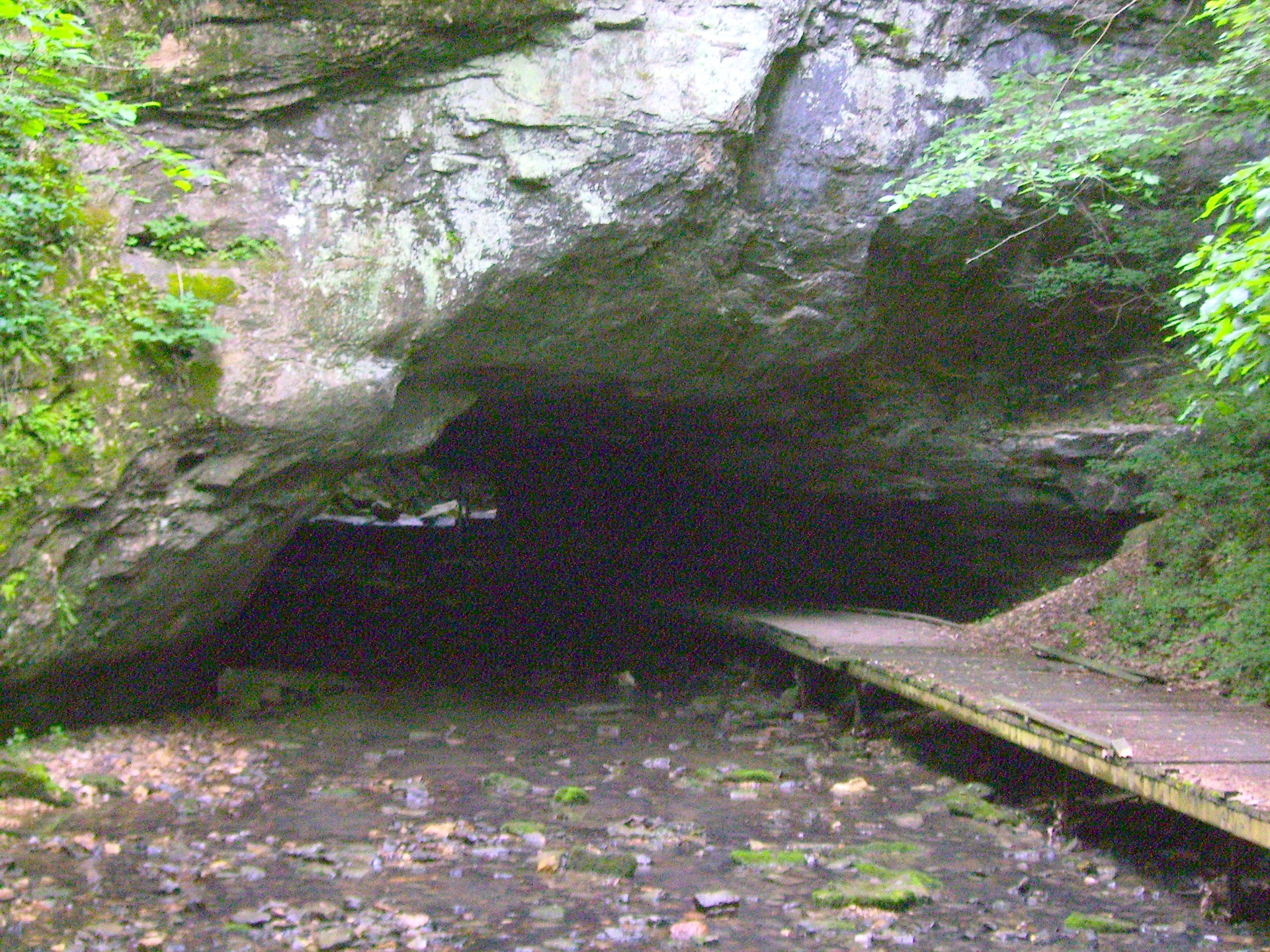