FREMONT PEAK STATE PARK
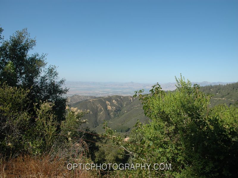
This park features expansive views of Monterey Bay, from its hiking trails in the grasslands of the higher peaks of the Gavilan Range. Other views include the San Benito Valley, Salinas Valley, and the Santa Lucia Mountains east of Big Sur. Pine and oak woodlands in the park are home to many birds and mammals. There are camping and picnic facilities in the park. The park also features an astronomical observatory with a 30-inch telescope, which is open for public programs on selected evenings.
Day-UseHiking Trailyes
CampingPrimitiveyes
Fremont Peak State Park is located near Castroville, Hollister and Marina
Fremont Peak State Park offers picnic areas with tables and BBQ grills, boasting scenic views of Monterey Bay.
Fremont Peak Trail
1 mile round trip
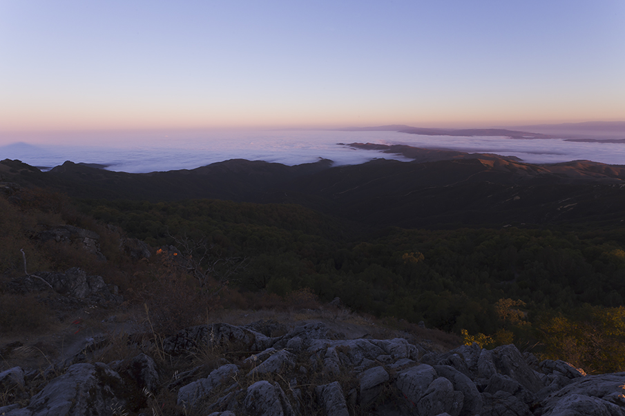
The view. That?s the reason?really, just about the only reason? travelers go so far out of their way to visit Fremont Peak State Park.
From atop 3,169-foot Fremont Peak, hikers are treated to a tremendous panorama of San Benito Valley, Monterey Bay and the rugged Santa Lucia Mountains back of Big Sur. The park also offers two more views: One is a glimpse into history and the part Captain John Charles Fremont played in the drama of California?s struggle for statehood.
Another view from the park is into the heavens. Fremont Peak Observatory houses a 30-inch reflecting telescope, one of the largest telescopes available for public use. Call the park for information about astronomy programs held during the spring, summer, and early fall viewing seasons.
In March of 1846, Captain Fremont and his men were camped near Monterey, then the capital of the Mexican province of Alta California. Mexican military leaders demanded that the Americans leave the territory. Fremont not only refused, but planted the American flag atop the tallest peak in the area and built a small fort nearby.
A war of nerves ensued before Fremont and his men finally broke camp. The incident reflects the kind of tension and jockeying for position between the rebellious Americans and the Mexican government in the years prior to the Bear Flag Revolt and California?s entry into the Union.
Fremont ultimately returned to California as military governor for a short time. His colorful career included a short stint as a U.S. Senator from California, a run for the presidency in 1856 as the first presidential nominee of the infant Republican party, and service as a general in the Civil War.
Before Fremont?s name was attached to the mountain, it was known as Gabilan Peak from the Spanish word for hawk. The state parks department acquired the peak in 1936.
Fremont Peak?s northern slope is cloaked with manzanita, toyon and scrub oak, while the exposed southern slope is covered with knee-high grassland that is bright green and dotted with wildflowers in spring, golden brown in summer. Soaring above the tops of Coulter pine and madrone on the upper ridges are eagles, hawks and turkey vultures. More than a hundred birds have been sighted in the park.
In light of Fremont?s talent as a wide-ranging explorer, trailblazer, naturalist and mapmaker (he was captain of the U.S. Topographic Engineers) the trail to the peak is all too bare. Nevertheless, the aforementioned grand view is reason enough for a walk in this off-the-beaten-path park. (Another good reason is the chance for motorists to stretch their legs while en route via Highway 101 from Los Angeles to San Francisco.) For a nice day, combine this short hike with a walking tour of San Juan Bautista State Historic Park, which features adobes, the original town plaza, Mission San Juan Bautista and the old Plaza Hotel, a stage stop.
Directions to trailhead: From Highway 101 north of Salinas and south of Gilroy, exit on Highway 156 and travel miles to the town of San Juan Bautista. From the outskirts of town, take the signed turnoff for the state park (San Juan Canyon Road) and travel 11 miles to road?s end at Fremont Peak State Park. Park in the uppermost lot.
The hike: You?ll see both a road and a trail beginning from the parking lot. The half mile trail, signed with a hiker?s symbol, does not go to the peak but instead, dips into then climbs out of a ravine, before switchbacking up to the park?s observatory.
Walk up the road for a short distance then join the signed Peak Trail, a footpath that contours around the mountain. Enjoy the view of Monterey Bay, as the path climbs to a saddle and meets a short summit trail that ascends to rocky Fremont Peak.
After taking in the view, return via the road, which passes by a communications facility before returning you back to the trailhead.
Astronomical Observing:
It?s best to arrive before sundown as vehicle headlights after sunset disrupt astronomers? night vision. Clouds or rain will cancel astronomy programs. Call the park for weather and program updates before you go.
In general, astronomers are friendly, outgoing, and happy to allow you to view through their telescopes and answer your questions. A few courtesies that will enhance everyone?s experience:
Do not touch any part of any telescope unless the owner instructs you on the proper method. In particular, do not touch any glass optical surfaces.
Please be sure that all children are supervised around telescopes.
Remember, using lights near telescopes at night is highly disruptive. A piece of red "cellophane" wrapped over the end of a flashlight and held in place with a rubber band works great.
Fremont Peak Day - April:
This annual event is an old fashioned picnic sponsored by the Veterans of Foreign Wars and the Native Daughters of the Golden West. The event commemorates Captain John C. Fremont and his expedition?s U.S. flag raising in 1846 in defiance of the Mexican government. The April event date varies, so please call the park for information.
Off of Highway 156, 11-miles south of San Juan Bautista on San Juan Canyon Road.


 Share Your Fremont Peak State Park Photos (click here)