GRAYSON HIGHLANDS STATE PARK
The park is adjacent to the Mount Rogers National Recreation Area, a part of Jefferson National Forest. Grayson Highlands State Park was originally named Mount Rogers State Park and was established in 1965. While pets are allowed in the park, they are not allowed inside public facilities including the bathhouses, visitor center and office.
Grayson Highlands, originally named Mount Rogers State Park, was established in 1965. The community overwhelmingly supported this park, beginning with a fund-raising effort for land acquisition and continuing with the donation of items on exhibit in the visitor center. Many areas in the park are named after early settlers. Massie Gap takes its name from Lee Massey, who lived in the gap with his wife and five children in the late 1800s and early 1900s. At that time, the present park area was thinly settled by people who managed to live off the land. They made, grew or gathered most of their necessities.
Wilburn Ridge is named after the famed hunter Wilburn Waters. His reputation as a bear hunter and wolf trapper made him renowned throughout the region.
Day-UseFishingyes
Huntingyes
Hiking Trailyes
Picnickingyes
Swimming Beachyes
Bridle Trailsyes
CampingPrimitiveyes
Water/Electric Sitesyes
WinterActivitiesyes
Nearly 10 miles of wild trout stream lie within Grayson Highlands State Park. The cool mountain streams offer those fishing breathtaking scenery while angling for native brook and wild rainbow trout. Several park streams are designated "Special Regulation Wildlife Trout Streams" thus require the use of a single hook and artificial lures, and all trout less than nine inches long must be released unharmed. All required state fishing licenses and creel limits apply to fishing within the park. A National Forest Permit is required when fishing on national forest property.
Big Wilson Creek, along the northeastern boundary of the park, offers 3.5 miles of fishable waters. From its headwaters to ?-mile below it confluence with Little Wilson Creek, the stream is designated a "Special Regulation Wild Trout Stream." A sign marks the area. Below this point, the creek is designated a "Stocked Trout Stream" and requires a trout license in addition to the state fishing license. You can reach the creek via the Appalachian Trail at Massie Gap or by taking the Big Wilson Creek Trail from the main campground.
Wilburn Branch, near the central area of the park, provides 1.8 miles of fishable waters and is designated a "Special Regulation Wild Trout Stream." It can be accessed via the Stamper's Branch or Upchurch Road trail.
You'll find Mill Creek, which has 1.1 miles of fishable waters, is the park's southeastern corner. It too is a "Special Regulation Wild Trout Stream." Get there by taking Highway 58 East from the park's entrance, then turning left on SR 742 (Mill Creek Rd.). Access to the park's portion of the creek is on the left near a grove of white pines, about half a mile down Mill Creek Rd.
Quebec Branch, in the park's northern region, has 1.1 miles of fishable waters, all of which is designated a "Special Regulation Wild Trout Stream." This waterway sometimes has low water. Access it from the Appalachian Trail at Massie Gap or by taking Wilson Creek Trail at the main campground to the Seed Orchard Road Trail.
Cabin Creek of the park's western area has 2.1 miles of fishable water. Wild rainbow and native brook trout inhabit the waters here; it's not stocked. Take the Cabin Creek Trail at Massie Gap to get there.
Grayson Highlands State Park is located near Marion
The picnic area is next to a rebuilt homestead site, complete with two log cabins, a spring-house and a cane mill. Picnic facilities include drinking water, grills and restrooms. Picnic shelters are available by reservation on a first-come, first-served basis by calling the Reservation Center at 1-800-933-PARK.
Grayson Highlands State Park Picnic Shelters
Two shelters are available for rent. They can be rented from 8 a.m. to 10 p.m. (all day). Click here for park fees.
Cancellation policy: No refund within 14 days before reserved date. Before then, there's a cancellation fee.
Amenities: Both shelters have grill, picnic tables and access to restroom.
Shelter one: Located in main picnic area. A water fountain and electric hookup is available at the shelter. Shelter can accommodate 100 people under the shelter. Seating for an additional 100 people is available around the shelter.
Shelter two: Located next to homestead cabin. Shelter is referred to as the Barn. No adjacent parking is available. Shelter can accommodate 100 people under the shelter. Seating for another 100 is available around the shelter.
Hiking, bicycle trails (mountain bikes only), horse trails, self-guided trails
Bridle trails: More than two miles of bridle paths wander through the park. These paths also lead to bridle trails in Jefferson National Forest. Parking facilities for horse trailers and overnight stables are available at the park. The park does not provide horses for trail rides.
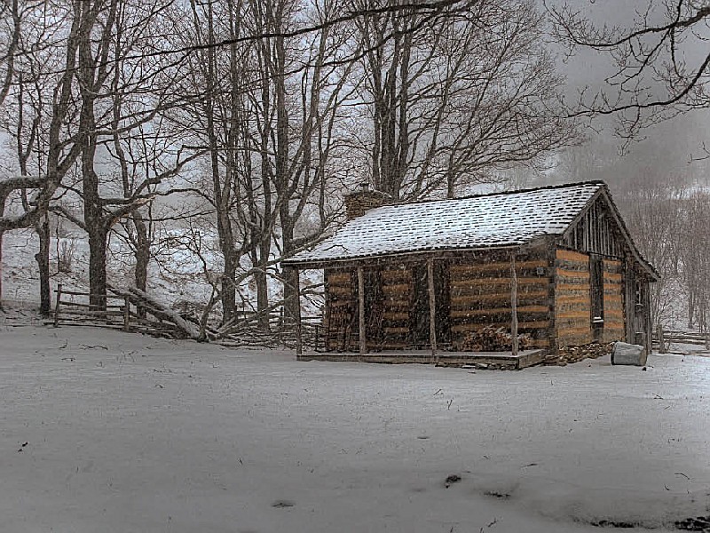
Hiking trails: The park has nine hiking trails averaging a mile in length. These trails lead to panoramic vistas, scenic waterfalls and a 200 year old pioneer cabin. The park also offers access to the Appalachian Trail and trails in the surrounding Jefferson National Forest. A list of trails and their mileage follows this section on Grayson Highlands State Park.
Birdwatchers can spot species like the Northern Saw-whet Owl, Red Crossbill and Golden-winged Warbler. The park is home to a variety of warblers during spring migration season. Raptors such as Broad-winged Hawks are also common in fall months. Winter brings sightings of finches and sparrows.
The park is on U.S. 58 midway between Independence and Damascus and is reached from I-81 at Exit 45 in Marion; turn south on Route 16 and travel 33 miles to US 58 in the community of Volney. Turn right onto US 58. Travel eight miles to the park's entrance.
From I-77, take Hillsville Exit 14 to U.S. 58. Travel west on U.S. 58, 40 miles to Volney. Turn left to stay on U.S. 58 and go eight miles to the park entrance.


 Share Your Grayson Highlands State Park Photos (click here)
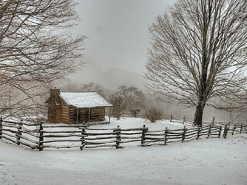